Satellite Images Show Destruction of Recent Boko Haram Attack in Nigeria
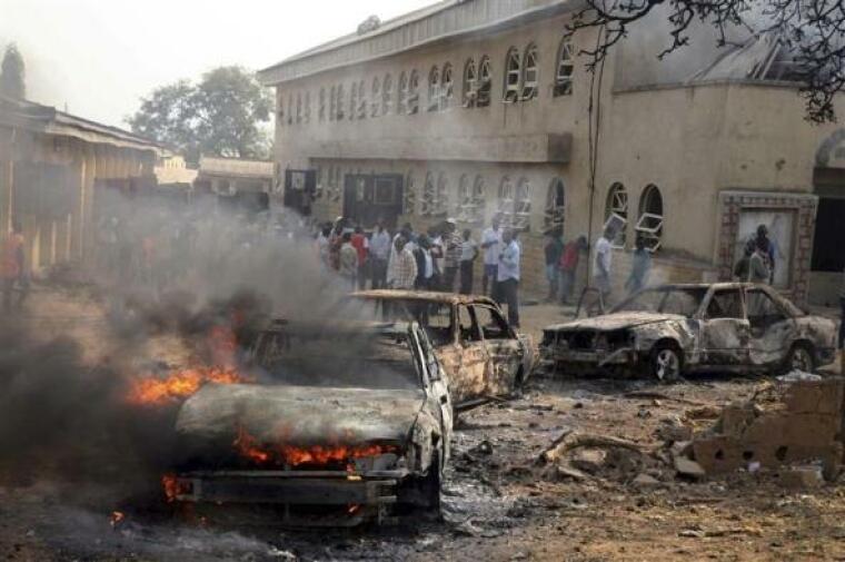
Recent satellite images taken over northern Nigeria show the recent destruction wreaked by the Boko Haram terror group that left 2,000 dead.
The international human rights group Amnesty International released satellite images from the site where Boko Haram attacked and burned the entire village of Baga, as well as surrounding villages in early January.
The rights group said in a recent press release that the attack, in which Boko Haram militants stormed Baga with machine guns and other heavy weaponry, caused 3,700 structures in Baga and neighboring Doron Baga to be destroyed or damaged.
Amnesty International adds that the satellite images "provide indisputable and shocking evidence" of Boko Haram's vicious attack, that has since only been told by surviving eyewitnesses, as government authorities have yet to make it to the remote village to properly assess the destruction.
The rights group adds in a recent press release that the small neighboring town of Doron Baga was "nearly wiped off the map" following the attack.
A death toll for Baga has yet to be determined, although witnesses have said that over 2,000 people were killed in the attack.
"They are more than 2,000 that died there," Garba Gagare, a butcher who sought refuge on the floor of his small business during the attack, told the Wall Street Journal. "I saw them with my own eyes. The dead bodies, on the streets. I'm not even counting those that were in the water."
The most recent attack in Baga is the latest of a string of vicious attacks on behalf of the Boko Haram Islamic extremist group in northwestern Nigeria.
 Christians don't have to affirm transgenderism, but they can’t express that view at work: tribunal
 Archaeology discovery: Medieval Christian prayer beads found on Holy Island
 Presbyterian Church in America votes to leave National Association of Evangelicals
 Over 50 killed in 'vile and satanic' attack at Nigerian church on Pentecost Sunday
 Ukrainian Orthodox Church severs ties with Moscow over Patriarch Kirill's support for Putin's war
 Islamic State kills 20 Nigerian Christians as revenge for US airstrike
 Man who served 33 years in prison for murder leads inmates to Christ


 Nigerian student beaten to death, body burned over ‘blasphemous’ WhatsApp message
 'A new low': World reacts after Hong Kong arrests 90-year-old Cardinal Joseph Zen
 Iran sentences Christian man to 10 years in prison for hosting house church worship gathering
 French Guyana: Pastor shot dead, church set on fire after meeting delegation of Evangelicals
 ‘Talking Jesus’ report finds only 6% of UK adults identify as practicing Christians
 Mission Eurasia ministry center blown up in Ukraine, hundreds of Bibles destroyed: 'God will provide'
 Church holds service for first time after ISIS desecrated it 8 years ago
 Burger King apologizes for 'offensive campaign' using Jesus' words at the Last Supper
 Uganda: Muslims abduct teacher, burn him inside mosque for praying in Christ’s name